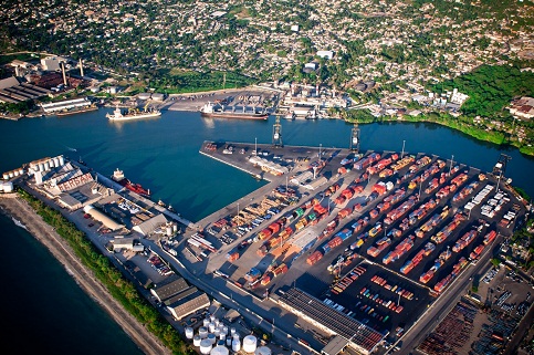
San Pedro de Macoris
Southeast Zone
Its infrastructure is located at the mouth of river Higüano, at latitude 18 ° 26 N and longitude 69 ° 18 W, so it is in qualifying natural harbor. It has a draft of 9.3 meters deep, 90 meters wide at the entrance channel with a dock length of 810 meters and 310 meters circle maneuver.
It is the country's oldest commercial port, built in the late nineteenth century during the boom of the sugar industry in the region. Due to its proximity to the Dominican capital, this port received most of the goods from the United States and Europe due to the inability of the Port of Santo Domingo to address the movement of vessels in past decades.
At present this terminal is in the process of remodeling, mainly used in the operations of bulk cargo, bulk cargo to cement, fertilizers and fuel for power plants. Terminal features the San Pedro de Macoris, Terminal CEMEX and Sultana del Este
Geographical Position
- Lattitude: 18º - 27. ‘N
- Longitude: 69º - 18. ‘W
Technical Data
- Time Zone: -4 GMT
- Tidal Variation: 0.50 M
- Ports Depth: 8.97 Mts
- Berths Depth: 19-20 ft
- Arrival Channel Depth: 19 Pies (6 Metros)
- Manioubre Circle: 275 Mts.
- Number of Berth: 4
- Security: PBIP Code
- Beacon: 8 buoys ( 1 landfall, 4 green , 3 red)
- Lining: 3270 by 0.62 MN (1255 yds)
- Lighthouse:N/A
Operations
- Load and Unload
- Importing dry bulk clinker , coal and fertilizer
- Export : Sugar and molasses , cement in bags
- Receiving tourist vessels